|
Transportation, utility and infrastructure services in San Joaquin County are conducive to sustained economic growth and development. The quality of service provided by suppliers, both public and private, is excellent; costs are well within state and regional averages.
The information contained within this pamphlet is general and introductory in nature. Specific surveys of utility and infrastructure costs/rates will be provided by the San Joaquin Partnership on request.
FOR MORE INFORMATION CONTACT
Shelley Burcham, Vice President, Client Services
The San Joaquin Partnership (209) 956-3380 or toll free at (800) 570-JOBS
Email: sjp@www.sjpnet.org
|
DISTANCE TO SELECTED CITIES
| CITY |
Approx. miles |
Drive Time (hrs.) |
| Bakersfield |
229 |
4.16 |
| Denver |
1231 |
22.38 |
| Fresno |
122 |
2.21 |
| Lake Tahoe |
146 |
2.65 |
| Las Vegas |
511 |
9.29 |
| Los Angeles |
337 |
6.12 |
| Monterey Bay |
134 |
2.43 |
| Phoenix |
721 |
13.10 |
| Reno |
181 |
3.29 |
| Sacramento |
40 |
.72 |
| San Francisco |
83 |
1.50 |
| San Jose |
67 |
1.21 |
| Seattle |
813 |
14.78 |
TRUCK/RAIL DAYS
| CITY |
Truck Days |
Rail Days |
| Bakersfield |
1 |
1 |
| Denver |
3 |
4-5 |
| Fresno |
1 |
1 |
| Lake Tahoe |
1 |
3 |
| Las Vegas |
2 |
2-3 |
| Los Angeles |
1 |
2 |
| Monterey Bay |
1 |
3 |
| Phoenix |
2 |
2-3 |
| Reno |
1 |
3 |
| Sacramento |
1 |
2 |
| San Francisco |
1 |
3 |
| San Jose |
1 |
3 |
| Seattle |
3 |
4-5 |
|
HIGHWAY TRANSPORTATION
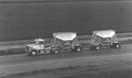
An excellent highway transportation system links San Joaquin County to the major California urban markets with same-day delivery service. San Joaquin County is a major Northern California distribution point where two primary north-south highways, Interstate 5 and Highway 99, meet and are joined by the Stockton Cross-town Freeway and Highway 120 through Manteca. Interstate 5 is the main north-south route for freight movement along the west coast from Canada to Mexico. Highway 99 is the main inland route through California connecting major cities in the San Joaquin Valley.
The County is well connected for east-west transportation with Interstate 580 running to Oakland and the San Francisco Bay Area. Interstate 80 links San Joaquin County to Reno, Nevada and points further east. San Joaquin County's ground transportation infrastructure is enhanced by the presence of hundreds of major trucking lines and contract carriers.
RAIL TRANSPORTATION
San Joaquin County is a confluence point for two national rail lines, the Burlington Northern Sante Fe and Union Pacific Railroad. The County is also served by three local railroads. Reciprocal switching agreements between lines provides local firms with efficient service. The computerized Union Pacific Railroad intermodal facility averages 200-250 container crane transfers per day. The Burlington Northern Sante Fe intermodal facility, completed in 2001, averages more than 600 container lifts daily. Daily passenger rail service via Amtrak is available from Stockton to San Francisco, Los Angeles, Sacramento and points in between.
WATER TRANSPORTATION
The Port of Stockton, located on the Stockton Deepwater Ship Channel, 75 nautical miles due east of the Golden Gate Bridge, the Port of Stockton, California, owns and operates a major, diversified intermodal transportation center that encompasses more than 2000 acres of operating area and real estate. The Port has over 11,000 lineal feet of waterside docking for vessel berthing and cargo operations. There are 40 miles of rail track which can be served by the Union Pacific Railroad (UP) or the Burlington Northern Santa Fe Railroad (BNSF). On-dock rail and rail service to more than seven million square feet of warehousing are both available, including over 700,000 square feet that is waterborne transit shed warehousing. Dry bulk, break bulk, and general cargo shipments compose the largest percentage of the Port's dockside operations. Stockton's deepwater channel has a designed depth of 35 feet at mean low water based upon U.S. Army Corps data. Panamax-sized vessels with load capacity up to 45,000 ton dead weight class fully loaded and partially loaded 80,000 ton dead weight vessels can be accommodated. There is no width restriction of vessels, and ships up to 900 feet in length can navigate the Stockton Ship Channel. The Port is one mile from Interstate 5 and all interconnecting major highway systems. Rail service is provided through two transcontinental railroads: UP and BNSF. The nearest port of entry for container cargo is the Port of Oakland.
AIR TRANSPORTATION
The Stockton Metropolitan Airport serves corporate and general aviation aircraft. It can accommodate large jet transports via an 11,037-foot primary instrument runway and a 4,458-foot general aviation runway. Approximately 250 private aircraft are based at the Stockton Airport. Allegiant Air offers flights to Las Vegas three times a week.
San Joaquin County residents are within a one-hour drive of Sacramento International Airport and Oakland International Airport. The San Francisco International Airport is also within convenient driving distance. The accessibility of these major airports gives San Joaquin County excellent air service to all major national and international centers.
|